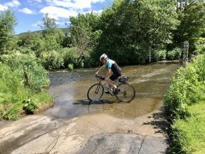
A hazard to one cyclist is normal riding to another. To get to some of the beautiful places we take you, you can expect plenty of potholes and loose gravel, with some lanes growing grass in the middle of the road. Some ascents will be very steep and some descents also, with a few sharp blind bends which may well hide an approaching vehicle.
The Highland Challenge remains an un-signposted, un-marshalled ride without warning signs before potential hazards: you are responsible for your own safety. But we do inspect the route when preparing the route card and warn you about what we consider to be exceptional hazards. For instance, these hazards were highlighted on the 2022 route:
At mile: | Hazard |
0.4 | At the left onto Coronation Ave from The Linney, traffic arrives suddenly from the right |
0.6 | Turn right across traffic after the petrol station |
10.5 | Steep descent to giving way at xRDS after Heath Chapel where you turn L SP Abdon |
11 | Some bad potholes ca. ½ mile (after above L at xRDS SP Abdon), and on bends entering Abdon village in a further ½ mile |
14.3 | Loose gravel on descent to T junction in Ditton Priors |
16.2 | Bad potholes 1 mile after Village Hall feed station |
16.3 to 18.3 | The 2 miles after turning left after Middeton Priors (SP Lower Netchwood, Hudwick, Monkhopton) are most dangerous of Challenge: gravel on fast bends, potholes, grass in road, steep blind bend descents |
21.8 | Nasty junction exit sharp R with obscured view at Bourton onto B4378 |
24.6 | Steep descent on B4378 into Much Wenlock |
24.7 | Beware pedestrians on Much Wenlock High St |
28.7 | Easy to miss left turn off the speedy B4375 descent out of Benthall |
28.7 to 29.4 | Long steep bendy descent with some uneven surface, from Benthall to the Iron Bridge. Dismount on the bridge. |
35.4 | Bad pothole 100 yards after turning left (SP Longwood, Garmston, Eaton Constantine) |
64.4 | L turn onto busy A49 Trunk road |
65.9 | R turn across Coronation Ave carriageway |